HMAS Melville surveys Shoalwater Bay

HMAS Melville aptly marked World Hydrography Day at sea on June 21, as the hydrographic survey crew continued operations in the Shoalwater Bay area.
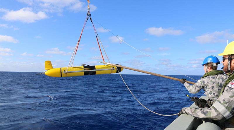
FILE PHOTO (Nov 2019): HMAS Melville crewmembers deploy a Slocum Glider. Story by Sub Lieutenant Meeka Brooks.
Melville’s current work will improve charting accuracy and strengthen the knowledge of local tidal dynamics within the central-Queensland coastal region.
The importance of the deployment is crucial to the continued appreciation of the changing environment, particularly by the forces that participate in Exercise Talisman Sabre, which is conducted in the area every second year.
Melville’s Executive Officer Lieutenant Commander Adrian Eddy said that with a better understanding of the space above and below the water, warfighters could take advantage of the information provided – both tactically and strategically – to allow them to gain the edge over an opponent.

“Our supporting role is to collect, decipher and disseminate to those who require it for decision-making purposes, either in real time or the more traditionally known methodical survey,” Lieutenant Commander Eddy said.
In 2019, Melville first deployed three Slocum Gliders as part of the SEA 2400 trials to collect deep oceanographic data over a four-week survey period.
In tune with this year’s theme of autonomous technologies, Melville deployed the gliders again on World Hydrography Day.
Maritime geospatial officer – hydrographic Lieutenant Djena Jordan has been conducting survey operations on board Melville since 2018.
“These gliders are piloted remotely from Western Australia by military and civilian personnel and can provide critical real-time data for planning purposes,” Lieutenant Jordan said.
“Autonomous technology that can be launched locally, yet piloted remotely, is an invaluable tool in gleaning accurate information.”
Melville will finalise survey work in another part of the area in the coming weeks with updated tidal and bathymetric information.
By understanding what lies beneath the water, hydrographers allow maritime units to navigate more confidently.
.
.
.
.
.
.

.
.