Tiger’s recce role in Queensland fires

As a part of wider effort, military members from the Australian Army’s 7th Brigade and 16th Aviation Brigade deployed in support of Queensland and New South Wales Fire and Emergency services.
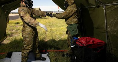
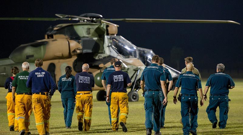
CAPTION: Emergency Service personnel from across Australia receive a brief on the thermal imagery capability of the ARH-Tiger helicopter as aircraft from the Army School of Aviation continue to provide specialised reconnaissance support to help identify and combat the bushfires in the Yeppoon Area. Photo by Trooper Jonathan Goedhart. Story by Major Matt Grant.
As a part of wider effort, military members from the Australian Army’s 7th Brigade and 16th Aviation Brigade have deployed in support of Queensland and New South Wales Fire and Emergency services.
In Queensland, Tiger helicopters, aircrew and mission support personnel have assisted through flying specific fire-mapping missions at night to supplement Queensland Fire and Emergency Service (QFES) activities.
At night, the cooler air provides an opportunity to map the fire perimeters so QFES fire-predicting specialists can analyse them.

What they glean from this data helps better deploy firefighters where they are needed and with the right plan of action.
Acting Chief Superintendent Kevin Reading, from QFES, said Tiger helicopter crews were flying a number of profiles during the night, using the aircrafts’ manoeuvrability to tightly map the fire lines.
“The accuracy being provided by the Tiger aircrews is first class,” Acting Chief Superintendent Reading said.
“They have been able to value-add to our operations in Queensland by gathering information through late-night missions that we then assess in the early morning and, ultimately, pass on to the firefighters on the ground at the start of their day.”
As well as linking in with the QFES mapping software, Army Tiger crews have also been able to provide thermal imagery of potential flare-ups they have detected during their missions.
In Queensland, Tiger helicopters, aircrew and mission support personnel assisted through flying specific fire-mapping missions at night to supplement Queensland Fire and Emergency Service (QFES) activities.
At night, the cooler air provides an opportunity to map the fire perimeters so QFES fire-predicting specialists could analyse them.
What they gleaned from this data helped better deploy firefighters where they were needed and with the right plan of action.
Acting Chief Superintendent Kevin Reading, QFES, said Tiger helicopter crews were flying a number of profiles during the night, using the aircrafts’ manoeuvrability to tightly map the fire lines.
“The accuracy being provided by the Tiger aircrews is first class,” Acting Chief Superintendent Reading said.
“They have been able to value-add to our operations in Queensland by gathering information through late-night missions that we then assess in the early morning and, ultimately, pass on to the firefighters on the ground at the start of their day.”
As well as linking in with the QFES mapping software, Army Tiger crews have also been able to provide thermal imagery of potential flare-ups they detected during their missions.
.
.
.
.
.
.
.
.