Laser-shooting drone penetrates the depths

A laser-shooting sensor on Navy’s eye in the sky mapped the seabed and beach for amphibious landings as part of a trial on Exercise Sea Raider.
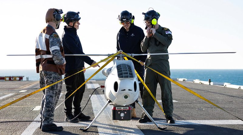
CAPTION: S100 crew from 822X Squadron and Defence Science and Technology Group personnel discuss the S100 bathymetric LiDAR sensor trials on the flight deck of HMAS Adelaide during Exercise Sea Raider. Story by Corporal Luke Bellman. Photo by Able Seaman Rikki-Lea Phillips.
An S100 unmanned aerial system was fitted with a bathymetric light detection and ranging (LiDAR) sensor, which used green wavelength laser beams to penetrate water and create littoral and terrain geospatial surveys.
The trials investigated the optimal balance between flying low to collect data in comparison to tactical flying.
Lieutenant Commander Thomas Lennards, from the Australian Amphibious Force, was exposed to the laser technology thanks to his work implementing hydrographic and geospatial collection for the S100.

“We generate survey plans for landing areas, then create 3D flight profiles and gradients, either electronically or paper, which are used as a briefing tool of shallow water bathymetry, beach, back of beach topography,” Lieutenant Commander Lennards said.
“The surveys are used to navigate hazards, beach entry and exit points, helicopter landing zones, bridges, hinterland and terrain.
“We have overlays of nautical charts and satellite imagery used to make sure the information is current with our collection and compare anomalies with what’s scanned compared to what is charted.”
Geography scientist Dr Alexander Lee, along with his team, attached the sensor as part of the S100 introduction into service trials on board HMAS Adelaide.
“We participate in major exercises to understand how the outputs of scientific research can be accelerated through the transition into operational use. This seeks to make the war fighter more effective for their missions,” Dr Lee said.
“It’s about talking to people, either day or night, to better understand how science can be used to resolve issues or identify new opportunities to enhance the effectiveness of the ADF.”
Dr Lee was trialling hand-held laser scanners that provided 3D views of beaches, forests and terrain that can be used for detection analyses, including battlefield damage assessment.
“The data it generates allows us to better understand the limits of the LiDAR data collected from airborne platforms like the S100,” he said.
The S100 has a range of 200km and can be used day or night in most weather conditions, navigating via pre-programmed GPS waypoints or by a control unit.
They also have the ability to integrate into a ship’s system, assisting air traffic control and gathering intelligence.
The Defence Science and Technology Group engages closely in exercises to research new capabilities and concepts.
“Pretty much everything that ADF does, there’s probably a scientist that’s looking into it,” Dr Lee said.
.
.

.
.