
Billion dollars for geobbildigook support system
Share the post "Billion dollars for geobbildigook support system"

The Morrison Government today sought to play up an investment of $150 million in the first tranche of Army’s geospatial support capability – a project that is already years behind schedule.
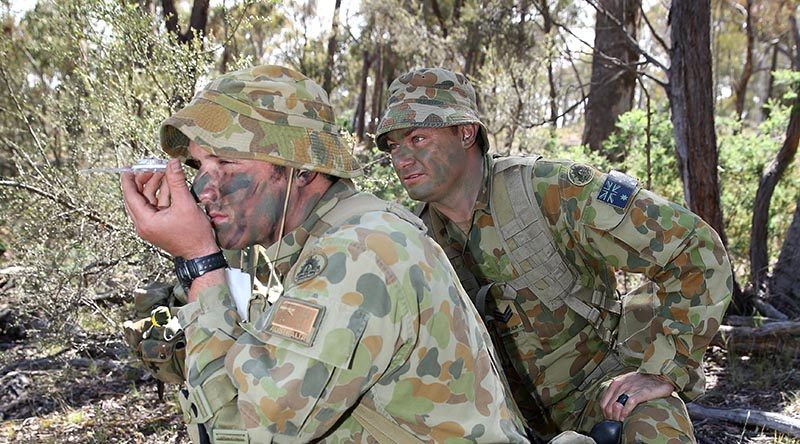
CAPTION: Staff Cadet Neil Fletcher shoots a compass bearing, supervised by Sergeant Wane Swan, at the Majura Training Area. Photo by Corporal Max Bree.
Minister for Defence Linda Reynolds said that under Project LAND 1771 Tranche 1, land forces would be able to use advanced imagery to obtain vital terrain and navigation data, resulting in Army commanders making faster decisions on the battlefield.
“The Morrison Government is investing in the best possible capability to meet the current and emerging threats of our changing geostrategic environment,” Minister Reynolds said.
“The new Geospatial Support System will not only ensure our land forces are more effective and efficient, but will also keep our serving personnel safer on operations by providing commanders with a greater understanding of their operating environment.

“We are investing around $500 million in acquisition and $400 million in sustainment of Army’s geospatial capabilities over the next 15 years.”
Minister Reynolds gave media a handy link to further information on Project LAND 1771 – which hasn’t been updated for more than two years and tells of delays in delivering the capability.
Unfortunately, the minister’s press release doesn’t clarify or update when final operational capability can be expected – though the out-of-date web page she pointed to expects it [perhaps optimistically] in May next year.
Neither the minister’s press release nor the handy web page made it clear [to this layman] what the project is actually about, or why it will cost almost a billion dollars.
.
.
.
.
.
.

.
.
Share the post "Billion dollars for geobbildigook support system"
I can the benefit of the system but its obvious like the NBN the muppets managing the project are not the end users and literally have no idea of how important it is, let alone what reasonable price is.
Who wants to take on a bet that the $1 billion will see every vehicle with a hard copy of Hema’s Australia 4WD book and and their mobile phone app?
Hema will just get their street price but a bunch of “consultants (that’s Australian for thieves)” pick up $1m per copy per vehicle?
A Billion dollars for a better google maps equivalent? Satellites imagery and drones provide real time updates on geographical information. 1. If a situation arises are we saying dont depend on US satellites – so we need our own 2. Start looking for “Black” projects – A Billion dollars is a lot of money.
We are all incredibly dependent on American GPS satellites which are quite visible and a lovely fat array of easily spotted targets. Well once again we should not try and stand on UncleSams Shoulders. We really should devise a system of Nano- Satelites of our own. That way if American GPS is damaged ours could backup America and visa versa. It makes good sence. I would feel much happier to know the system is backed up, wouldn’t you.